Strategy & Guidance USAID Geospatial Strategy USAID’s 2024-2028 Geospatial Strategy promotes leveraging the power of geospatial data and technology to target the delivery of international programs. November 15, 2023
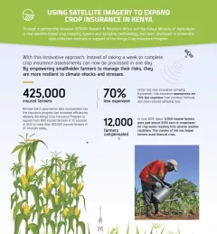
Infographic Using Satellite Imagery to Expand Crop Insurance in Kenya Through a partnership between SERVIR Eastern & Southern Africa and the Kenya Ministry of Agriculture, a new satellite-based crop mapping system and sampling methodology was developed to streaml October 23, 2020
Strategy & Guidance SERVIR Strategic Plan 2020-2025 This strategic plan identifies the next set of cross-cutting strategic priorities that will ensure SERVIR remains responsive to both NASA and USAID Agency goals and those of stakeholders and users in SERVIR regions. October 10, 2020
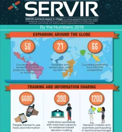
Infographic SERVIR by the Numbers: 2018 SERVIR by the Numbers 2018 provides a visual glance of SERVIR's work up through 2018. April 23, 2019