
ICIMOD and SERVIR contribute to official decision in Nepal to lower dangerous glacial lake
Research from a SERVIR Applied Sciences Team (AST) project and from scientists at the International Centre for Integrated Mountain Development (ICIMOD), the SERVIR-Himalaya organization, guided a United Nations Development Programme (UNDP)-funded project that informed Nepali officials' decision to lower the water level in potentially dangerous Imja Lake. The move is expected to reduce the risk of outburst flooding – and help save lives and infrastructure in downstream villages*.
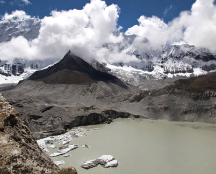 |
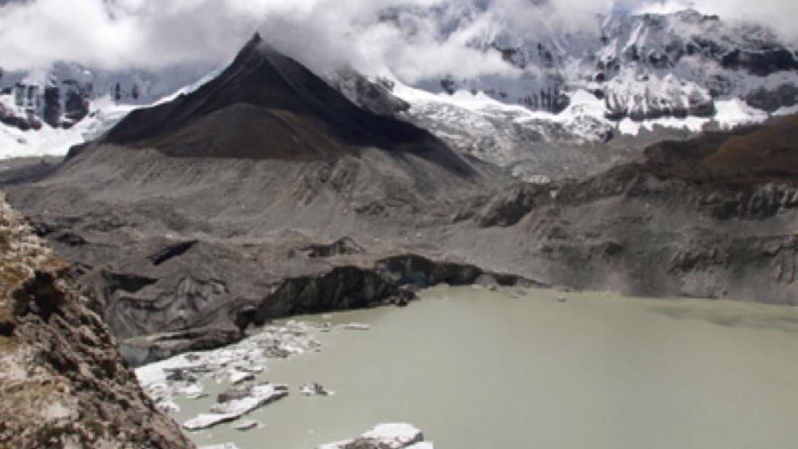
| Imja Lake in Nepal |
Located near Mount Everest, Imja is a typical large glacial lake created by a moraine dam**. An article in the Kathmandu Post highlighting the signing of a contract to lower the lake calls Imja “one of the fastest-growing and potentially dangerous glacial lakes in high altitude regions.”*** In addition to posing a potential threat to villages below, it is positioned above an extremely popular trekking destination that attracts thousands of people each year. A glacial lake outburst flood, or GLOF****, here could be disastrous.
After the devastating earthquakes of April and May 2015 in Nepal’s Gorkha region, SERVIR AST principal investigator Jeffrey Kargel (U. Arizona) teamed with ICIMOD to study lakes at risk for GLOFs. Based on their findings, the team co-authored a report, especially targeted for policy officials, about earthquake-induced hazards and the condition of glacial lakes. The report included an overview of Imja Lake and Lower Barun Lake results as well as an earthquake-triggered landslide study. The researchers found no immediate new dangers, but with monsoon seasons each year, risks could escalate. Existing damage to the terrain caused by last year’s earthquakes could reroute water, cause erosion, and trigger new landslides or an outburst flood.
In 2014, the team’s previous Imja Lake data and satellite image analysis guided a UNDP-funded project to determine the feasibility of a potential Imja Lake Lowering project to reduce risk of GLOFs. For this effort, Kargel, Gregory Leonard (U. Arizona), Dhananjay Regmi (Himalayan Research Expeditions), and their colleagues conducted thorough bathymetric and land surveys and satellite remote sensing analyses of Imja Lake and its glacier setting. They also analyzed several prior expeditions worth of data to build a detailed assessment of the glacier and lake to better understand their evolution – and the lake’s future GLOF potential.
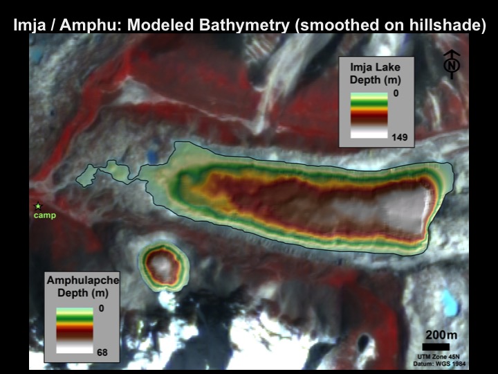 |
| A bathymetric (lake depth) map from the recent survey is shown above, superposed on an EO-1 ALI image dating from before the earthquake. |
Their most recent bathymetric survey of Imja Lake revealed a much greater volume (75,200,000 cubic meters) and maximum depth 492 feet (149.8 m) than found before. The research team obtained new data indicating the presence of unstable ground ice in the damming moraine, and made new calculations describing how possible landslides into the lake might generate waves that could overtop and undermine the moraine dam, heightening concerns over the lake’s safety.
Based on their findings, the Department of Hydrology and Meteorology in Nepal signed a letter of agreement on March 25, 2016, with the Engineering Department of Nepal Army to lower the water level by 3.5 meters.
“It’s not that all possible Imja GLOF scenarios would result in utter destruction,” says Kargel. “‘Slow GLOFs’ generated somewhat gradually by partial moraine melt-through might last as long as several hours to a full day, limiting peak flows and downstream damage.
“The major villages downstream from Imja Lake are situated just outside of and above a deep, broad outwash and debris-flow channel system. Imja and other glaciers in the area have built a large fan, now deeply trenched, which could accommodate the peak discharges of any potential slow GLOFs, sparing the villages.”
However, "fast GLOFs" are another story.
“A fast GLOF could be caused by a tsunami initiating a large mass movement of ice, dirt, and rocks into Imja Lake,” says Kargel. “Resulting waves could override and damage the end moraine in less than a couple of minutes. Villages downstream would be very vulnerable to such a "fast GLOF."”
Kargel notes that the lake lowering project will not eliminate the GLOF hazard but will reduce the chances of a GLOF occurring as well as lower the magnitude of any GLOF that might occur. Similar projects in Peru and at Nepal’s Tsho Rolpa have successfully reduced the occurrence of devastating GLOFs.
Notes:
* The Kathmandu Post says an estimated 96,562 vulnerable people in Solukhumbu and the downstream Tarai and Churia districts of Mahottari, Siraha, Saptari and Udaypur are expected to directly benefit. Read the Kathmandu Post article: http://bit.ly/1Snww9V. (Published: 27-03-2016)
** A moraine dam is formed when dirt and rocks transported and deposited by a glacier are cemented by ice, and then the glacier retreats up valley from behind the moraine, leaving a lake in its place.
*** The lake was described as “one of the fastest-growing lakes in the Himalaya” in Impact of Climate Change on Himalayan Glaciers and Glacial Lakes: Case Studies on GLOF and Associated Hazards in Nepal and Bhutan (2007) Shrestha, B.; Mool, P.K.; Bajracharya, S. R. as well as in subsequent papers by the same authors.
**** A GLOF happens when the moraine dam containing a glacial lake fails. If water levels rise or climate change melts the ice in the dam, the dam can become weaker and may give way because of the pressure of the water, resulting in a GLOF. Also, if ice from the retreating glacier or ice or rock from high on adjacent mountain slopes falls rapidly into the water, the resulting waves can quickly wear down the dam and trigger a GLOF.