
SERVIR-Mekong adds key tools for environmental monitoring
Recently, the SERVIR-Mekong team added three new tools to aid in the environmental monitoring of the Mekong River Basin. These tailor-made applications are designed to better inform natural resource management and decision-making, especially after the effects of the extreme drought experienced in the region recently.
Eco-Dash (https://servir.adpc.net/tools/eco-dash) is a land monitoring application that uses MODIS images to compare the biological productivity of areas across periods of months to years using the Enhanced Vegetation Index (EVI). The original intent of this tool was to gauge the success of environmental policies and sustainability projects that have been implemented in the region, though the applications can go far beyond assessment. For example, this tool can be used to monitor changes in urban expansion and infrastructure development and related impacts on biological productivity. By monitoring these changes over time, decision makers will be able to make adjustments to their planning and policies as needed to achieve the best result.
"The Eco-Dash allowed us to do a fast and cost-effective analysis on the biophysical health of the Vietnam Forest and Deltas (VFD) intervention areas,” notes Dr. Ate Poortinga, a hydrologist at SERVIR-Mekong. “We were happy to see that the areas where we work show fast improvement compared to the baseline condition and country average. This tool is very helpful to report biophysical improvement in the project areas to USAID."
The Surface Water Mapping tool (https://servir.adpc.net/tools/surface-water-mapping-tool) uses a combination of different satellite images and cloud-based software to identify permanent bodies of water as well as flood extent and changes in river flow. This tool uses historical data to map the information, providing users the ability to analyze and identify potential trends in surface water in the region. Understanding how surface water interacts with land features can highlight areas at risk of different environmental hazards such as seasonal flooding or prolonged droughts. Urban planning, energy infrastructure, and agriculture are only a few of the sectors that would benefit from this comprehensive tool.
One of the most highly anticipated tools is the Dam Inundation Mapping tool (https://servir.adpc.net/tools/dam-inundation-mapping-tool), which uses hydrological modeling and ArcGIS to show the extent of land to be flooded depending on placement and height of dams throughout the Irrawaddy, Salween, Mekong, and Red River basins. Dams are often helpful in terms of electricity production, drought and flood risk reduction, and improved crop production, but they can also alter water regimes, contribute to the loss and degradation of natural forests and biodiversity, and reduce soil and water quality. The Dam Inundation Mapping tool provides decision makers with information needed to ensure that dam construction in Southeast Asia is part of a sustainable growth pathway that allows communities to thrive.
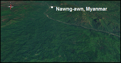
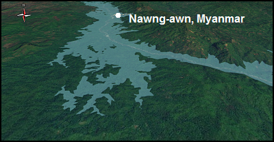
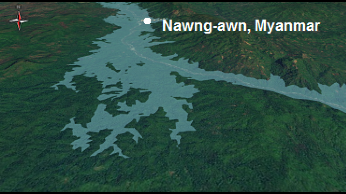
Output from the Dam Inundation Mapping tool for the proposed TaSang Dam in Myanmar: The first image shows the Salween River region
as it looks currently, with no dam, and the second image reveals the expected extent of flooding upstream when the dam is built.
This suite of decision support tools helps to close the gaps in information needed to optimize the outcomes of environmental decision making in the Lower Mekong region. All three tools are live on the SERVIR-Mekong website hosted by the Asian Disaster Preparedness Center (ADPC) and can be accessed by anyone with an internet connection. SERVIR-Mekong consortium partners Spatial Informatics Group (SIG), Stockholm Environment Institute (SEI), and Deltares along with a range of co-developers played significant roles in the design and development of these tools with ADPC and their stakeholders.
These applications are dynamic and have a variety of uses that can be expanded upon in the future for use in other regions, or used in combination with each other to provide even more valuable information about the state of the environment.
This article was written by SERVIR graduate research assistant Thailynn Munroe and edited by the SERVIR Science Coordination Office.
