
SERVIR Flood Mapping Service Brings Speed to Cambodia Disaster Management
This post was written by Jake Ramthun from the NASA SERVIR Science Coordination Office, and was originally featured on Climatelinks. Click here to go to the original blog post.
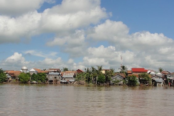 |
Rising sea surface temperatures are causing rainfall extremes and making floods an increasingly common occurrence in Cambodia. Image credit: EU Civil Protection and Humanitarian Aid, CC BY-SA 2.0 |
Flood preparedness is a moving target — often literally. Natural river shifting and human changes to the landscape can drastically redirect floodwaters from year to year, making anticipating flood paths extremely tricky. Because rising sea surface temperatures are fueling more frequent and severe rainfall extremes, faster flood mapping is in high demand. This is often prohibitively expensive and difficult, but a webtool from SERVIR-Mekong and the Asian Disaster Preparedness Center (ADPC) is helping disaster managers in Cambodia stay ahead.
Floods in Cambodia killed at least 42 and affected over 175,000 families in October of 2020. “Cambodia is one of the most hazard-prone countries in Southeast Asia,” says Nyein Soe Thwal, an ADPC geospatial scientist. “The government still has many limitations due to the lack of resources to prevent, mitigate, and adequately respond to floods, leaving them particularly vulnerable.” Moreover, the scale of the flooding and threat of additional rains creates challenges for the Cambodian government and partners like the United Nations World Food Programme (WFP), who must manage flooding across thousands of square miles affecting nearly a million people. Fast, detailed mapping at that scale once seemed impossible.
This challenge brought WFP Cambodia together with SERVIR, a partnership between USAID and NASA that provides state-of-the-art, satellite-based Earth monitoring data, geospatial information, and tools to help improve environmental decision-making among developing nations. SERVIR-Mekong primarily implements services through the ADPC in consortium with Spatial Informatics Group, Deltares, and Stockholm Environment Institute. They work across five Lower Mekong nations, building capacity to manage climate risks and fostering disaster resilience.
The new Hydrologic Remote Sensing Analysis for Floods (HYDRAFloods) service, co-developed by SERVIR-Mekong consortium members and the SERVIR Science Coordination Office improves the frequency and resolution of map updates. With the new HYDRAFloods tool, maps automatically update into the Platform for Real-time Impact and Situation Monitoring (PRISM), an online hazard monitoring platform that the Cambodian government and WFP launched this year with support from USAID’s Bureau for Humanitarian Assistance. Now, new information disseminates faster with updates that automatically transmit to decision-makers, improving on the delivery of timely and accurate information.
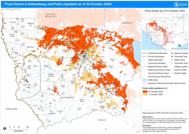
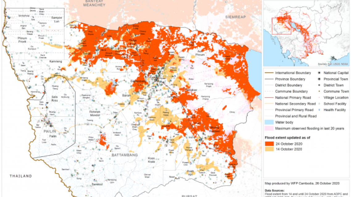
A map of Battambang, Cambodia from the Humanitarian Response Forum situation reports demonstrates
the extent of flooding (dark orange) and was made using HYDRAFLoods data. Image credit: World Food Programme
Peeranan Towashiraporn, Chief of Party for SERVIR-Mekong, says flood responders urgently need real-time data. “Historically, such data would come from reports up from communities to the local governments and sometimes all the way to the national government before a response and relief effort could be mobilized. That took a lot of time and sometimes the specific location information was missing.”
Previous satellite-based methods could only update every few days. HYDRAFloods draws from multiple satellites on different schedules, thus procuring imagery more often. SERVIR-Mekong and ADPC are working to further improve its speed and accuracy by working with additional data providers.
Kurt Burja, Programme Policy Officer for WFP Cambodia, says that increased frequency of maps from HYDRAFloods makes it easier to distribute situation reports to humanitarian partners and local governments. “[HYDRAFloods] enabled the Cambodian government, WFP and humanitarian partners to better understand the geographic extent of the floods over time and target emergency assistance where it was most needed.” This assistance includes short-term efforts, such as distributing essential supplies and assisting displaced families, but also long-term recovery management and the development of future response plans. Burja says HYDRAFloods made it possible to “produce estimates of the population affected by the floods to guide the immediate response...and inform the formulation of a more comprehensive response plan.”
HYDRAFloods is a scalable service that is being replicated and used elsewhere, extending its value beyond Cambodia. For example, in collaboration with NASA’s Applied Sciences Program, HYDRAFloods data was provided to Central American governments following Hurricane Eta. Anywhere local resources are overburdened, HYDRAFloods could supplement local and international flood mitigation efforts.