
Locally Led Development Drives Climate Action at the SERVIR Amazonia Hub

The SERVIR Amazonia hub is based at the Alliance of Bioversity International and the International Center for Tropical Agriculture (CIAT) in Cali, Colombia1. To date, the hub has developed 11 geospatial services collaborating with more than 30 partner organizations across the Amazonia region. Among the 30 partner organizations, 23 are formal partners and constitute the SERVIR Amazonia Consortium, and 20 are based within the six focus countries (Brazil, Peru, Ecuador, Colombia, Guyana, Suriname). The four main hub partners below implement the program directly in focus countries:
- Spatial Informatics Group (SIG), based in California
- Conservación Amazónica (ACCA), based in Peru
- Institute for Forest and Agriculture Management and Certification (IMAFLORA), based in Brazil
- Fundación EcoCiencia, based in Ecuador
SERVIR Amazonia supports sustainable development throughout the Amazon region by strengthening the capacity of governments and other key stakeholders through the integration of Earth Observation and geospatial technologies. The hub strives to build capacity to improve decision-making and to better incorporate the voice of women, indigenous peoples and their communities.
Below are a few examples of how SERVIR’s Amazonia hub is working with local governments and communities to manage challenges – in areas of food security, water resources, weather and climate, land use, disasters, and air quality – that are increasingly made more difficult by a changing climate.
Working with Local Authorities to Monitor Illegal Gold Mining in the Peruvian Amazon
In the Peruvian Amazon, SERVIR Amazonia created a service that monitors illegal gold mining throughout the region. The service application (RAMI) is used in the region of Madre de Dios by local authorities to produce near real-time information on deforestation and activity due to mining in the southern Peruvian Amazon. The service development is led by the Peruvian NGO Conservación Amazonica (ACCA).
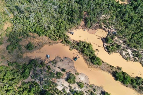
Gold mining sites in La Pampa, Peru. Credit: Conservación Amazónica (ACCA)
Protecting Forests Managed by Community Organizations in the Brazilian Amazon
In the Brazilian Amazon, SERVIR Amazonia created a service that was designed as an application – TerraOnTrack (Increase the Protection of Forests Managed by Community-Based Initiatives in the Brazilian Amazon) – that will allow 180 traditional community organizations of the Brazilian Amazon to quickly identify potential threats to their territories and monitor illegal activities on the ground, which in turn will increase forest protection and territorial management capacity. The service development is led by the Brazilian NGO IMAFLORA.
Collaborating with Government Organizations and Academia to Monitor and Evaluate Mangroves in Guyana
In Guyana, SERVIR Amazonia created the service “Monitoring and Evaluation of Mangroves in Guyana,'' which aims to promote forest and biodiversity conservation across the country. This service maps the extent and structure of mangrove forests along the coast of Guyana. Co-developed directly with governmental organizations and academia of Guyana, it provides data needed to act on hotspots of deforestation, engage in land-use planning, policy making, and other actions to protect mangroves and the people that the ecosystem supports, such as farmers in low-lying coastal regions. The service development is led by NAREI and University of Guyana.
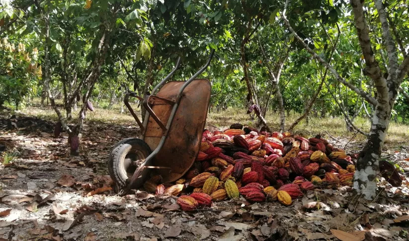
Supporting Cacao Producers to Expand Crops in Deforested Areas in the Peruvian and Brazilian Amazon
In the Peruvian and Brazilian Amazon, SERVIR Amazonia established a new service, Ecosystem Services Modeling in The Amazon's Forest-Agricultural Interface, which is led and financed by NASA’s Jet Propulsion Laboratory. The service works directly with cacao producers in Peru and develops a prototype tool that utilizes accurate plantation maps, allowing stakeholders to understand crop expansion over deforested areas and to assess farmer compliance with Zero Deforestation Supply Chain initiatives.
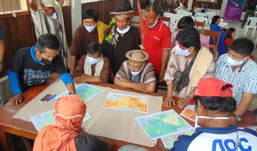
Documenting the Effects of Forest Changes for Indigenous and Traditional Communities in the Peruvian and Brazilian Amazon
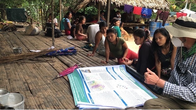
Indigenous women and David Salisbury use an ABSAT NASA SERVIR poster to discuss the importance
of women’s leadership on health, education, and environment in the context of a road threatening
their Indigenous community (November 2021). Photo credit: David Salisbury, University of Richmond
In the Peruvian and Brazilian Amazon, SERVIR-Amazonia created the service Quantifying the Effects of Forest Changes on Provisioning and Regulating Ecosystem Services, which allows regional and local planners and decision-makers, as well as citizens of Acre and Ucayali (including the indigenous and traditional communities of the Sierra del Divisor, Yurua, and Purus watersheds), to better understand the tradeoffs between development activities and ecosystem services. This service, which is supported by an Applied Science Team member at the University of Richmond, has documented the effects of forest changes due to infrastructure projects in trans-frontier areas in the Amazon. Maps are delivered to local and indigenous communities in those regions to support their community efforts in protecting their biodiversity.
Through the combined efforts of regional hubs, and with technical support from USAID, NASA, and U.S.- based science collaborators, SERVIR has been front and center at promoting locally led development and climate action around the world. The SERVIR Global network demonstrates the value of Earth Observation and collaborative science and is strategically placed to support these new climate initiatives of the U.S. government and USAID. To learn more about how SERVIR’s locally led development is driving climate action across its five hubs, click here.
1A joint initiative of NASA and USAID, SERVIR works in partnership with leading regional organizations worldwide to help developing countries use information provided by Earth observing satellites and Earth science to address development challenges in food security, water resources, weather and climate, land use, disasters, and air quality.
-
Ecosystem Services Modeling in the Amazon's Forest-Agricultural Interface
The Ecosystem Services Modeling in the Amazon's Forest-Agricultural Interface service provides accurate maps for stakeholders and decision-makers to understand how agricultural production can lead to deforestation, particularly due to palm oil and cacao production.
-
Increase the Protection of Forests Managed by Community-based Initiatives in the Brazilian Amazon (TerraOnTrack)

TerraOnTrack is a web application developed as part of this service to help traditional communities and indigenous people to quickly identify potential threats to their territories and monitor illegal activities on the ground.
-
Quantifying the Effects of Forest Changes on Provisioning and Regulating Ecosystem Services
Quantifying the Effects of Forest Changes on Provisioning and Regulating Ecosystem Services is a service that allows stakeholders to better understand the tradeoffs between development activities and ecosystem services.


