
Land Use Land Cover and Change Mapping Service for Eastern and Southern Africa
The Land Use Land Cover and Change Mapping Service seeks to provide governments with data, tools, and skills to better understand relevant intervention actions related to land conservation and management, ensuring that land resources can be efficiently monitored and regulated. The service draws on the immense catalog of earth observation data for monitoring land use and land cover change including ENVISAT, IKONOS, Landsat, MODIS, VIIRS, SRTM, WorldView, GeoEye, Sentinel 1, Sentinel 2, and Radarsat. Together, these satellites provide a comprehensive picture of the landscape in ten countries. To support the service, SERVIR developed land use land cover maps and products, greenhouse gases accounting information, data supporting REDD+, apps to enhance data collection processes, and visualization tools to increase awareness and access to available data.
The effects of unmanaged land are widespread, and communities become the greatest victims of uncontrolled land developments, including an increased risk of flooding in deforested regions, poor air and water quality, human wildlife conflict over scarce resources, and land degradation. This service equips decision makers with the data and tools needed to mitigate the effects of climatic, non-climatic, and anthropogenic factors contributing to changes in land cover and land use.
Rationale
Changes in land cover and land use in East Africa are driven by a number of factors, with climate change and anthropogenic factors being the major contributors. Climatic factors contributing to land cover changes include erratic weather patterns and changing climate. Non-climatic factors contributing to the problem include conflicting policies, lack of synergies and coordination among stakeholders, lax enforcement of policies, and undervaluation of ecosystems. Anthropogenic factors include a growing population whose demand for agricultural land is resulting in poorly planned land use changes that lead to land degradation and fragmentation. Other anthropogenic factors include uncontrolled land subdivisions, infrastructure development, mining, charcoal burning, sedimentation, poverty, firewood extraction, overexploitation of forest services, and poorly coordinated changes in land tenure. These issues result in the need to effectively map and monitor land use and land cover changes through time to inform better policy and management decisions.
-
Users
Kenya Water Towers Agency
Northern Rangelands Trust
Rwanda Land Management and Use Authority
Rwanda Water and Forest Authority
Kenya Forest Service
Kenya Wildlife Conservancies Association
Kenya Forest Service
Uganda National Forestry Authority
Ministries of Environment and Forest Departments in Botswana, Ethiopia, Kenya, Lesotho, Malawi, Namibia, Rwanda, Tanzania, Uganda, and Zambia
Conservation International
World Bank
Universities
-
Data Products
Botswana Land Cover 2000 Scheme I
Botswana Land Cover 2000 Scheme II
Botswana Land Cover 2010 Scheme I
Botswana Land Cover 2010 Scheme II
Ethiopia Land Cover 2003 Scheme I
Ethiopia Land Cover 2003 Scheme II
Ethiopia Land Cover 2008 Scheme I
Ethiopia Land Cover 2008 Scheme II
Lesotho Land Cover 2000 Scheme I
Lesotho Land Cover 2000 Scheme II
Lesotho Land Cover 2014 Scheme I
Lesotho Land Cover 2014 Scheme II
Malawi Land Cover 1990 Scheme I
Malawi Land Cover 1990 Scheme II
Malawi Land Cover 2000 Scheme I
Malawi Land Cover 2000 Scheme II
Malawi Land Cover 2010 Scheme I
Malawi Land Cover 2010 Scheme II
Namibia Land Cover 2000 Scheme I
Namibia Land Cover 2000 Scheme II
Namibia Land Cover 2010 Scheme I
Namibia Land Cover 2010 Scheme II
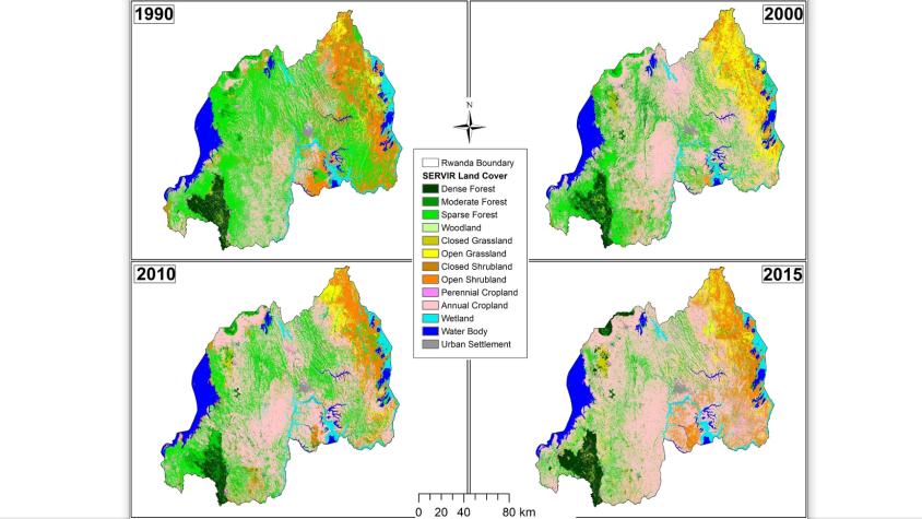
Rwanda Land Cover 1990 Scheme I
Rwanda Land Cover 1990 Scheme II
Rwanda Land Cover 2000 Scheme I
Rwanda Land Cover 2000 Scheme II
Rwanda Land Cover 2010 Scheme I
Rwanda Land Cover 2010 Scheme II
Rwanda Land Cover 2015 Scheme I
Rwanda Land Cover 2015 Scheme II
Tanzania Land Cover 2000 Scheme I
Tanzania Land Cover 2000 Scheme II
Tanzania Land Cover 2010 Scheme I
Tanzania Land Cover 2010 Scheme II
Uganda Land Cover 2000 Scheme I
Uganda Land Cover 2000 Scheme II
Uganda Land Cover 2014 Scheme I
Uganda Land Cover 2014 Scheme II
Zambia Land Cover 2000 Scheme I
Zambia Land Cover 2000 Scheme II
Zambia Land Cover 2010 Scheme I