
Improving the Mekong River Commission's Regional Flood Forecasting
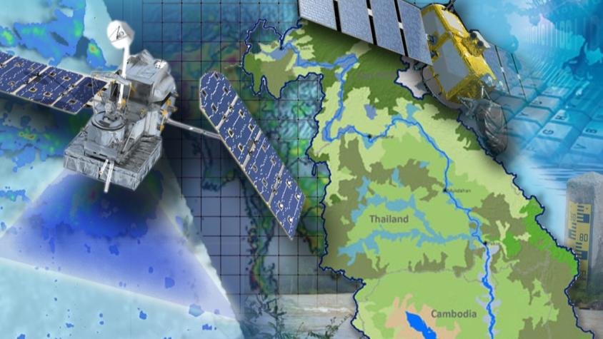
Through the Improving the Mekong River Commission's (MRC) Regional Flood Forecasting Service, SERVIR Mekong supported the MRC to use new-generation satellite-derived precipitation products to increase flood forecast accuracy. This service built upon MRC's current use of the Tropical Rainfall Measurement Mission (TRMM) data by generating and distributing provisionally bias-corrected Global Precipitation Measurement (GPM) precipitation data through the Virtual Rain and Stream Gauge Information Service (VRSGIS) for the MRC to use in their hydrologic model. The goal of this service was to improve the MRC's hydrologic model accuracy by including precipitation data with higher spatial and temporal resolution information to aid in flood forecasting efforts.
Current flood forecasting efforts use precipitation data collected by the decommissioned TRMM mission. This service focuses on incorporating the use of the GPM mission precipitation data which offers near real-time observations (within 3 hours), improved spatial, and temporal data coverage of precipitation than the previously used TRMM data. This service will work to regionally bias-correct the GPM data via VRGIS to make beneficial inputs available for forecasting and modeling flash floods. The SERVIR-Mekong and MRC teams will collaborate to demonstrate the benefits of the GPM data as well as implement its use within their flood forecasting workflow.
Rationale
The lower Mekong countries suffer from the effects of frequent seasonal flooding and flash flooding caused by monsoon rains and tropical storms. Regional and national level organizations and agencies require a range of information, forecasts, and decision-support tools to better prepare for, monitor, issue warnings, and respond to flood risk. This service works to improve the accuracy, spatial, and temporal coverage of precipitation data used for flash flood forecasting and monitoring efforts.
-
Users
Mekong River Commission (MRC)
National Mekong Committee
Cambodia: Department of Meteorology, Ministry of Water Resources and Meteorology, The Department of Hydrology and River Works
Lao PDR: Department of Meteorology and Hydrology, Ministry of Natural Resources and Environment
Thailand: Thai Meteorological Department, Ministry of Information and Communication Technology, Department of Water Resources, Ministry of Natural Resources and Environment
Vietnam: Highland Regional Hydro-Meteorological Center and Southern Regional Hydro-Meteorological Center, Hydro-Meteorological Service
-
Mekong River Commission Uses Space Technology to Improve Flood Forecasting

SERVIR-Mekong is supporting the Mekong River Commission (MRC) in using a new generation of satellite-derived precipitation products to increase flood forecast accuracy and lead time.
-
Use Case: Mekong River Commission (MRC)
The Mekong River Commission (MRC) is an intergovernmental organization that provides coordination and technical input on flood management to the members of the Lower Mekong countries including Cambodia, Lao PDR, Thailand, and Vietnam.

