
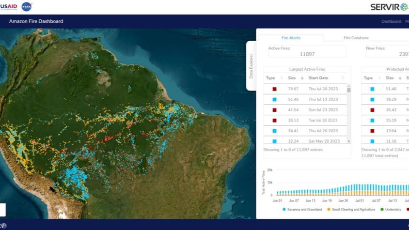
Forecasting Seasonal to Sub-Seasonal Fire and Agricultural Risk from Drought
The Forecasting Seasonal to Sub-seasonal Fire and Agricultural Risk from Drought service provides information for evaluating drought conditions at temporal and spatial resolution to predict fire vulnerability in the Amazon basin, helping stakeholders to mitigate the negative impacts of drought and fire on forests and agriculture. The service detects small and understory fires using several satellite platforms, including VIIRS and MODIS, with a focus on providing information products such as wildfire patterns and association with land use change events, helping to detect fires that current global algorithms often miss. The service helps stakeholders characterize fires and quantify their negative impacts on ecosystem services as well as use fire forecasting models to develop dry season metrics and predict how these metrics change over time.
Rationale
Extended dry seasons and drought are a threat to agricultural food systems and increase vulnerability to fires, one of the greatest hazards for tropical forests. The Amazon has a long history of fire detection work, including Brazil’s fire monitoring system, which provides fire hotspot data and risk analysis for all of South America. However, drought and fire forecasting tools and their impacts on reducing food insecurity in the region are produced at coarse scales, not always applicable for subnational management needs, and capacity at these levels is also sometimes lacking. Geospatial data and modeling, and associated capacity building, can create decision support services related to drought and fire risk that are relevant on regional, national, and subnational levels, allowing stakeholders to allocate resources more efficiently and effectively.
-
Users
Secretaria de Estado de Meio Ambiente do Acre - SEMA-AC - Brazil
Secretaria de Estado de Meio Ambiente e Sustentabilidade do Pará - SEMAS-PA - Brazil
Secretaria de Estado do Desenvolvimento Ambiental de Rondônia - SEDAM-RO - Brazil
Fundação Estadual do Meio Ambiente e Recursos Hídricos de Roraima - FEMARH-RR - Brazil
-
External News/Resources
-
StoryMaps
