
CONNECTING SPACE TO VILLAGE
SERVIR HOME SANDBOX
Locally led. Globally connected. Lasting impact.
Through regional hubs across Africa, Asia, and Latin America, SERVIR co-develops operational services that strengthen locally-led action on climate resilience, disaster preparedness, food and water security, and environmental stewardship.
We believe scientific innovation achieves lasting impact when it is embedded in trusted institutions, built on open science, and co-developed with the regional partners responsible for translating it into operational services.
What we do
SERVIR accelerates the journey from scientific innovation to operational impact.
We co-develop decision-support services with regional institutions, strengthen the capacity and partnerships needed to sustain them, and create pathways for successful innovations to be reused and scaled across regions. At the center of this approach are shared digital platforms that bring together Earth observation, geospatial science, and emerging GeoAI capabilities, reducing the time and cost of developing new services while allowing them to be adapted to local needs.
We are Working on
Global Risk
Brings together information on hazards, exposure, and vulnerability to support risk assessment, early warning, preparedness, and better-informed decisions before, during, and after extreme weather and climate events.
Food Security
Combines information on crops, weather, water, and other factors to monitor agricultural conditions, anticipate threats to food production, improve production forecasting, and identify emerging food-security risks earlier.
Land Cover & Environmental Intelligence
Provides consistent monitoring of how landscapes are changing and what those changes mean for people and ecosystems, supporting forest and ecosystem management, conservation, restoration, agriculture, and sustainable land-use planning.
Our Objectives
SERVIR’s work is guided by five interconnected strategic objectives that strengthen the network’s ability to translate scientific innovation into trusted, locally-led operational services.
Strengthen Governance and Coordination
Build Shared Platforms and Digital Infrastructure
Advance Scientific Excellence and Innovation
Ensure Long-Term Sustainability
Demonstrate Impact
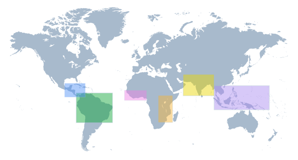
SERVIR REGIONS Where We Work
SERVIR works in more than 50 countries in Africa, Asia, Central and South America. In partnership with regional, technical organizations, SERVIR has established regional “hubs” within selected host institutions.
Service Areas
Food Security
The Food Security platform monitors agricultural conditions, anticipates threats to food production, and strengthens food security decision-making. It brings together information on crops, weather, water, and other factors to support agricultural monitoring, production forecasting, and earlier identification of emerging food security risks.
Land Cover and Environmental Monitoring
The Land Cover, and Environmental Monitoring platform strengthens our understanding of how landscapes are changing and what those changes mean for people and ecosystems. It supports consistent monitoring of land cover and land use to inform forest and ecosystem management, conservation, restoration, agriculture, and sustainable land-use planning.
Global Risk
The Global Risk platform brings together information on hazards, exposure, and vulnerability to support risk assessment, early warning, preparedness, and more informed decisions before, during, and after extreme weather and climate events.
Water Security
We advance reliable and equitable access to water through monitoring solutions that track both quantity and quality of water resources. Our platforms help partners sustainably manage surface and groundwater, plan for seasonal variability, and strengthen climate resilience in water supply systems.
Air Quality and Health
The SERVIR Global Collaborative’s regional hubs deliver solutions to track environmental conditions affecting public health. This includes monitoring the sources and spread of air pollution, identifying vulnerable populations, and supporting actions that protect health and enhance climate resilience.