
Passing the Earth Science Baton in Bhutan
After five connecting flights—8,000+ miles and over 40 hours of traveling—our flight descended into the “Land of the Thunder Dragon.” Our team from the SERVIR program made our way to the Himalayas to work with partners in Bhutan and demonstrate how NASA Earth observations and applied science approaches can align with the country’s unique environmental vision. Having grown up in the U.S., Bhutan certainly feels like a unique and rarified place. The legends of the towering snowy mountains, lush valleys, and unbelievably happy people are completely true. Also true are the legends of the harrowing descent into the country’s main airport. There is only one international airline that is allowed to fly into Bhutan, and I have heard tales that this measure is to ensure that only experienced Bhutanese pilots are guiding jets down through the narrow, twisting Himalayan valleys to reach the tarmac on the flat valley floor. Needless to say, I was very happy to have an experienced pilot at the yoke as we gracefully rolled and yawed down, cutting through the clouds and arriving in the amazing landscape of the Paro Valley.
The Kingdom of Bhutan is often known for its conservation and land management practices, and of course for its philosophy of “gross national happiness.” Bhutan is unique compared to other counties in that its constitution requires that 60% of the land remain forested to ensure social, economic, and environmental well-being for all. In addition, the country’s government famously follows a policy of measuring its progress not by its economic growth, but by the happiness of its citizens. This forward-leaning approach to both policy and the conservation of natural landscapes is just some of what makes Bhutan such a special place.
Since the 1970s, Bhutan has started to open its doors to foreign collaboration, and since the first democratic election in 2008, the Kingdom has made unbelievable strides to equip their next generation as regional leaders in science, technology, engineering and math (STEM), forestry, and sustainable agriculture—that’s where we align. SERVIR is a collaboration of NASA and the U.S. Agency for International Development. Our program assists communities in using geospatial science and Earth observing satellites to address and support their own environmental goals, collaborating with organizations to build tools that are demand-driven and tailored to local needs. The Department of State has been funding SERVIR to support STEM opportunities in Bhutan—but until now, that work has taken place entirely remotely through conference calls and webinars.
On paper, I was arriving halfway around the world to formally launch a new rice mapping tool and conduct capacity building trainings. But in the big picture, this visit really built the kind of connections with the Bhutanese community—university partners, NGOs, government agencies, as well as community members—that you just can’t achieve when combating an eleven-hour difference with a teleconference.
And you may ask yourself, "Well, how did I get here?"
Back in early 2020, the Department of State and NASA Headquarters identified the opportunity to collaborate and support STEM opportunities in Bhutan through NASA’s Applied Sciences Program. Bhutan has never had diplomatic ties with the United States, but SERVIR and I took on the challenge to lead STEM initiatives and begin to collaborate with partners in the country to collaborate on geospatial solutions to environmental challenges. Through these efforts, we also had the opportunity to build ties between our two countries.
You know what they say about best laid plans. COVID presented a distinct challenge as we halted all in-person events, but we found ways to keep the project moving forward. In 2021, NASA’s DEVELOP program started special 10-week projects to help Bhutanese students living in the U.S. grow their geoscience and remote sensing skills while working with organizations in Bhutan (Bhutan Highlight). I was the lead science advisor on some of these projects, and it was a great opportunity to form meaningful connections with the brilliant Bhutanese students and the burgeoning geospatial community in Bhutan, even if we couldn’t yet meet face to face. NASA’s GLOBE program also got involved, helping to set up Earth science and geospatial workshops tailored to Bhutanese participants.
With SERVIR, I continued working intensively with our partners at Bhutan’s Department of Agriculture, as well as advising for more and more Bhutan DEVELOP projects connecting with over 30 Bhutanese scholars studying in the U.S.
Fast-forwarding, after two-plus years of extensive remote co-development of a geospatial crop mapping service and four virtual trainings focusing on remote sensing and applied Earth observation efforts, the conditions were finally just right for travel. SERVIR began to plot out our trip. Set for May 2023, we worked tirelessly with the State Department’s Bhutan Affairs Unit with partners from the Bhutan Foundation to plan the visit. The foundation was extraordinarily helpful, and they connected us with the Bhutan Ecological Society (BES), who aided us in designing a joint “training of trainers” workshop and did the unbelievably heavy lift of supporting our SERVIR team with logistics. Both the Bhutan Foundation and the BES not only made it possible for this trip to even be possible, but they also made us feel truly welcome.
"Where does that highway go?"
A race against time, my entrance to Bhutan did not exactly proceed as originally planned. I was delayed a day en route, but my colleagues were thankfully able to arrive as scheduled. They met and became fast friends with our BES colleagues, starting off the journey with a tour. Twelve hours later, I got my connection in Kathmandu and when I touched down I was ready to run because our service launch was scheduled that same day. Floored by the sights, I ran to meet a representative from the BES who helped me hightail from Paro to Thimphu. After a two hour jaw-dropping road trip on a winding two-lane road, I made it just in time for our partners from the Ministry of Agriculture and Livestock and the Department of Agriculture to kick off the launch of the Agriculture Classification and Estimation Service (ACES).
The launch of the ACES tool was a centerpiece of our visit to the capital of Thimphu. ACES was built in collaboration with the Bhutanese Department of Agriculture and provides the country with an automated system to map rice fields. At the launch event, we were lucky enough to be joined by several high-ranking members of the Department of Agriculture. I was thrilled to see the enthusiasm and excitement for what we had created together. The Department of Agriculture was so impressed that they invited other higher-ups from the local government to get involved, and our training planned for the next week hit max capacity.
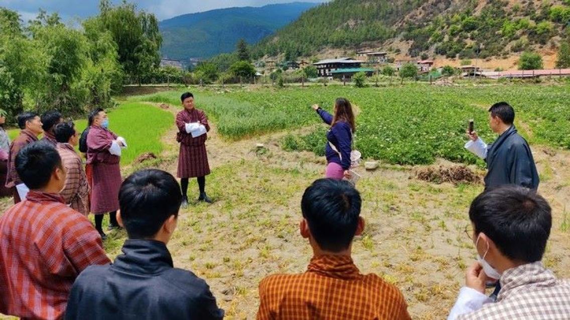
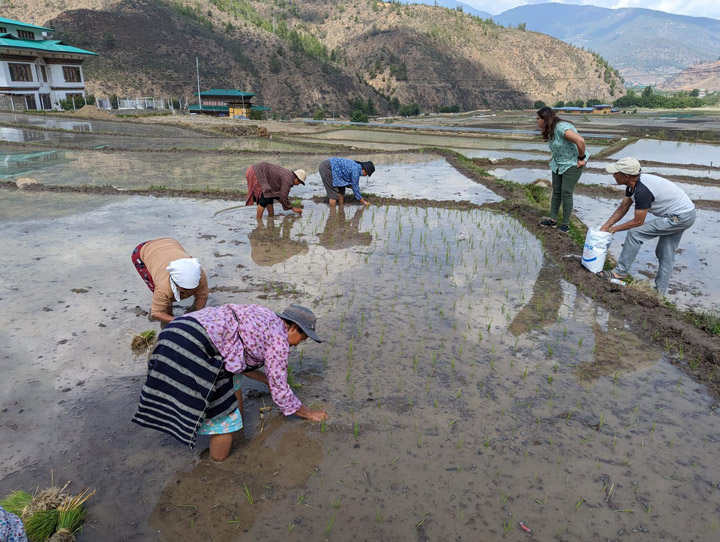
We then traveled back to the city of Paro to conduct a week-long training on using Earth observations and geospatial resources like ACES to manage agriculture. On the way, we crossed paths with a group of farmers as they were walking out to the rice fields, and they were kind enough to answer our questions. With the help of our interpreters, we were able to learn about the unique challenges of local cultivation, how communities cycle their crops, and the gender dynamics that influence local agriculture. We later were able to ask the same set of questions to the local Department of Agriculture, allowing us to understand these same topics from the perspective of the government. From these opportunities, we were able to come into our training with a deeper understanding and greater appreciation for what Bhutanese communities really want and need out of a rice-mapping tool.
With the help of the Bhutan Ecological Society, we had a full week to dive into the nuance and opportunities of using remote sensing, machine learning, and resources like Collect Earth Online. Thirty-one participants—20 men and 11 women—enrolled in the training, including regional land managers, economists, academics, and even some students. The training also included sections on field data collection using GeoFairy, a mobile application developed by Liping Di, a principal investigator with SERVIR’s Applied Sciences Team.
Throughout this process, participants from all of these different backgrounds shared their knowledge with our team so we could better understand the unique landscape and agricultural practices of Bhutan—knowledge we could take back with us to help SERVIR better serve the community with ACES and other resources. The opportunity to build ties between NASA and the Bhutanese STEM community was also incredibly rewarding. We were honored to meet over 100 students and faculty who attended a lecture we gave at the Royal Thimphu College. We visited the amazing Super FabLab, which provides STEM educational resources, including geospatial and Earth observations tools. Throughout our entire trip, we heard so much enthusiasm for NASA, and we were inspired by just how many people were excited to share ideas for future collaborations.
Once in a lifetime
The trip—with the ACES launch, lectures to students, and amazing week-long joint training with the Bhutan Ecological Society—was even more successful than we could have anticipated. With the connections we had newly minted between NASA and the Bhutanese STEM community, our SERVIR team left in a great position to continue to collaborate.
Four connecting flights and over 48 hours of travel time and I closed the loop to arrive back in Alabama, literally flying all the way around the world. It was an absolute pleasure and an amazing opportunity to visit the Kingdom and see the spectacular architecture and scenery. The landscape reminded me of the Columbia River Gorge, close to where I grew up in the Pacific Northwest, but with looming Himalayan mountains and rice fields as far as the eye can see. I always appreciate how much we at SERVIR have been able to accomplish by connecting virtually, but our time in Bhutan was a great reminder of just how much more we can achieve when we get the opportunity to meet our international colleagues face to face, and get a sense of their community needs. I met some amazing people as part of the trip and I cannot wait to return, as it truly felt once in a lifetime.
This article was originally published on the NASA Earth Observatory website. Click here to go to the original blog post.