
Seasonal water outlook and implications for farmers in the Indus basin
The cryosphere – snow, ice, and permafrost – is an important source of water in the Hindu Kush Himalaya. Observed and projected estimates of cryosphere show changes in the timing and magnitude of stream flows across the region. Snow is important for seasonal water availability, particularly in the early melt season, and is a critical source of water for irrigation for some 1.65 billion people living in the river valleys downstream.
ICIMOD used their snow product and similar methodology to estimate the recent snow accumulation in the HKH. Snow accumulation during the winter of 2021-22 remained highly variable across the river basins of the HKH (Fig 1). Overall the central Tibetan Plateau and its surroundings received above-normal snow and the rest received under- or below-normal snowfall. In the west, the Amu Darya and Indus basins received significantly below-normal snowfall (Fig 2). The northeastern region of the Yellow River basin shows extreme snow accumulation deficit.
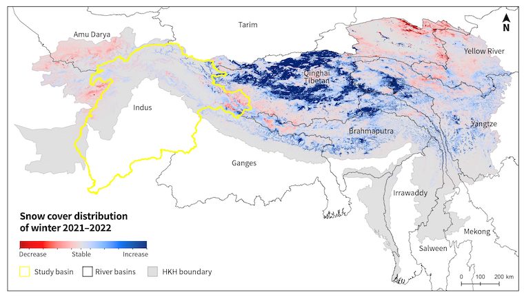
Figure 1: Snow accumulation anomaly during the winter of 2021-2022 across the extended HKH region. |
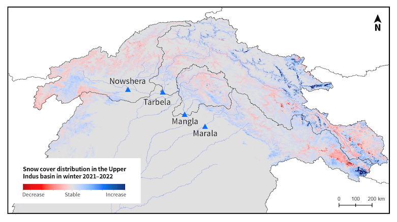
Figure 2: Snow accumulation anomaly during the winter of 2021-2022 in the Upper Indus basin. |
It is estimated that snow and glacier melt contribute more than 50% of total flow in the Indus Basin Irrigation System – the world’s largest contiguous irrigation system, which irrigates some 2.5 million acres. Anomalous accumulation of snow and glacier melt in the upstream could have major impacts on agricultural production and socioeconomic development downstream. Snow accumulation in 2022 remained below average particularly in the eastern part of the Indus and over the entire Kabul River sub-basin. Snow extent in parts of the valley floors appears to be above average, but it has insignificant water equivalent and is susceptible to melt in early spring.
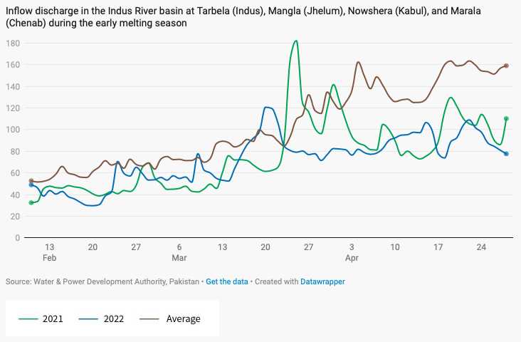
Figure 3: Inflow discharge in the Indus River basin at Tarbela (Indus), Mangla (Jhelum), Nowshera (Kabul), and Marala(Chenab) during the early melting season. (Source: WAPDA) |
Snowmelt and subsequent streamflow is a function of higher temperatures in spring and early summer in the high altitudes. This year, spring temperatures were exceptionally high across the entire basin, including in the high altitude areas. The upper elevations of Astore, Chilas, Gilgit, Gupis, and Dir experienced record daily maximum temperatures in March. Similar conditions were observed in April. Significantly low discharge (Fig 3-4), mainly in the Kabul, Jhelum, and Chenab rivers, despite the high temperatures, further validate the snow accumulation deficit observed using the MODIS snow product. The situation was further compounded by deficit rainfall in March-April 2022, which remained below normal across Gilgit Baltistan, with ~ 40 % deficit in March 2022 alone. On 28 April, the river discharge at Tarbela, Nowshera, Mangla, and Marala was 28.7, 14.1, 20.0 and 12.3 thousand cusecs respectively, while the 10-year average for these locations is 37.0, 41.2, 52.3 and 26.3 thousand cusecs, respectively. On the same day, the daily maximum temperature observed was 25.6 °C, while 10-year average daily maximum temperature for Skardu, Gilgit-Baltistan is 20.3 °C.
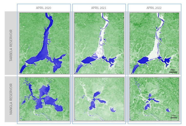
Figure 4: A comparison of Water Extent (WE) in the Tarbela (top) and Mangla (bottom) reservoirs in April over three years (2020-2022). Based on Sentinel-2 satellite data.
Tarbela and Mangla dams are two major reservoirs in Pakistan with a combined capacity of 15 million acre feet (MAF), crucial for the world's largest contiguous irrigation system. Towards the end of April 2020, the water extent in Tarbela reservoir was 163 km2; it was 53 km2 for the corresponding period in 2021, and at its lowest at 44 km2 in April this year. In comparison to 2020, the reservoir extent reduced to 33% in 2021 and to 27% in 2022. Similarly, the water extent in Mangla dam was 230 km2 in April 2020, 83.5 km2 in April 2021, and at its lowest at 43.3 km2 in April this year. In comparison to 2020, the reservoir extent reduced to 36.3% in 2021 and 18.8% in 2022. On 28 April, the reservoir levels of Tarbela and Mangla were 1,392 ft and 1,074 ft, respectively. The present levels are just above the minimum operating level of 1386 ft for Tarbela and 1050 ft for Mangla.
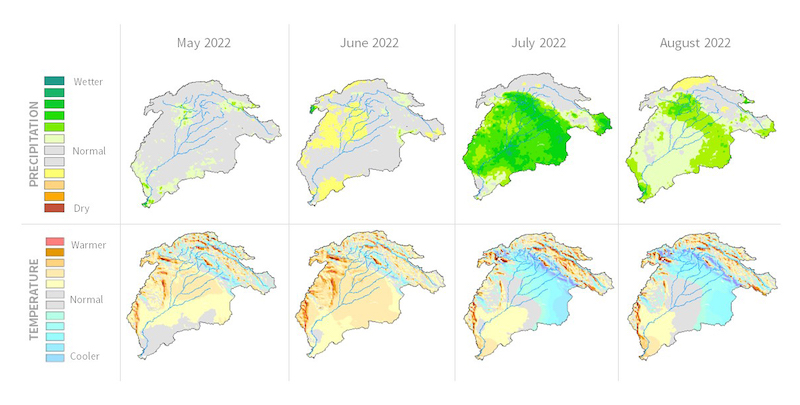
Figure 5: Seasonal precipitation and temperature outlook of the Indus basin — for the upcoming 2022 kharif season.
According to the Regional Drought Monitoring and Outlook System, the four-month rainfall outlook from May to August indicates overall near-normal conditions, which will remain variable throughout the four months. Precipitation in June, which is critical for the planting of kharif crops, is expected to remain below normal. In July, most parts of the basin will experience wetter conditions. Much of the basin will experience above normal temperatures in May and June. Central areas of the basin are expected to transition to normal or below normal temperature conditions in July and August. Most of the high elevation regions across the basin are showing warmer than normal temperatures for the four months. In the context of ongoing short interval extreme heatwave events, it is important to note that such short-term meteorological events cannot be predicted and therefore cannot be captured in the seasonal outlook. The predicted higher temperatures across the basin suggest increased chances of surges, glacial lake outburst floods (GLOFs), and associated hazards.
The observed deficit in winter snow accumulation followed by the dry spring months (March and April) has resulted in acute decline in water storage in the Tarbela and Mangla reservoirs. The anticipated near normal monsoon rainfall is unlikely to compensate for the water storage deficit. Rather, anticipated warmer than normal temperatures in the basin will increase crop water demand. Furthermore, March and April remained exceptionally dry and hot resulting in the depletion of soil moisture, which will increase the need for irrigation water during planting in June. As a result, June also appears as a water stressed month.
Such water shortages are becoming more frequent. During the 2018 kharif season, reduced water inflows at the Tarbela and Mangla reservoirs resulted in a 30% reduction in irrigation water supply. This led to below normal crop growth overall; wheat and maize production saw declines of 5 and 7 percent, respectively. Sugarcane and cotton crops faced water stress conditions and delays in cane crushing caused huge losses to farmers. Such losses can be minimized by informing farmers about expected water shortages and guiding them in decisions related to crop choices and water use planning.
In response to the growing climate-related challenges in Pakistan’s agriculture sector, we have noticed that institutions are modernizing their monitoring, forecasting, and information dissemination systems to improve resource management practices under increasingly uncertain climatic conditions. The Indus Basin Model Revised (IBMR), operated by the Water and Power Development Authority (WAPDA) of Pakistan aims to forecast seasonal inflows, storage, and operational planning at the start of every season, and manage allocation-demand issues while maintaining equitable sharing between provinces. Similarly, there are several other initiatives like agromet data products from the National Agromet Centre (NAMC) and the National Drought Monitoring Centre (NDMC) at the Pakistan Meteorological Department; the GIS-based near-real time Irrigation Water Management Information System at the Punjab Irrigation Department; and the Ground Water Information System created by the Pakistan Council of Research in Water Resources (PCRWR). Thus, numerous data and information services do exist, and are being used for agriculture-related institutional decision making. Although these national-level information systems serve the agriculture sector, in isolation their use is limited in comparison to their potential. Smallholder farmers in Pakistan’s remote areas in particular lack access to timely information on seasonal scale water availability and associated advisories to prepare and adapt to emerging conditions. There is an urgent need for establishing a mechanism to deliver science-supported, timely, and locally relevant agro-climatic advisories to inform and support on-farm decisions by farmers. Also, inter-departmental collaboration is needed to exploit the full potential of individual data services through ICT-enabled integrated information platforms.
This article was originally featured on SERVIR HKH's website. View the original post.
