
Three Ways SERVIR is Supporting Biodiversity in the Amazon

May 22 is World Biodiversity Day, and this year we’re highlighting SERVIR’s commitment to protecting biodiversity in the Amazon Rainforest. SERVIR’s Amazonia hub collaborates with organizations across the region to support locally-led biodiversity conservation efforts.
1. TerraBio
TerraBio uses a novel “eDNA” approach to track biodiversity. eDNA, short for “environmental DNA,” is a method that involves taking soil samples from different sites in the Amazon and measuring the diversity of DNA present in the sample as a proxy for the forest’s overall biodiversity. Scientists can then compare this data to maps of land use and forest conditions to understand how changes in the land–such as agroforesty or nearby farming practices–change biodiversity and forest health. The program is designed to help organizations understand how their land management projects impact the biodiversity of the forest around them.
SERVIR Amazonia uses satellite imagery and radar to help coastal communities in Guyana and Ecuador keep track of the health of mangrove forests. The forests not only contain unique ecosystems of plants and marine life, but also help protect coastal communities from erosion and flooding. Synthetic aperture radar (or “SAR”) emits sound waves from satellites off of forests to ‘feel’ conditions like forest coverage and tree height, allowing users to understand changes in the mangroves over time. Communities can then use this information to understand where mangroves are at risk and better conserve these diverse ecosystems.
3. Radar Mining Monitoring Tool
The Radar Mining Monitoring Tool, or RAMI, is a near-real time detection tool that tracks illegal gold mining in the Peruvian Amazon and in the state of Pará, Brazil. These informal mines clear patches of forest and spill heavy metals into rivers, endangering local wildlife. Illegal gold mining increasingly occurs during the rainy seasons because these operations are less likely to be detected by rangers or aerial surveillance when there is heavy cloud cover. Unlike other satellite applications that only use optical imagery, RAMI uses synthetic aperture radar data that is able to ‘feel’ changes in the land through the clouds. RAMI alerts are used by local enforcement agencies to deter gold mining operations year round, regardless of weather conditions.
-
Monitoring and Evaluation of Mangroves in Guyana
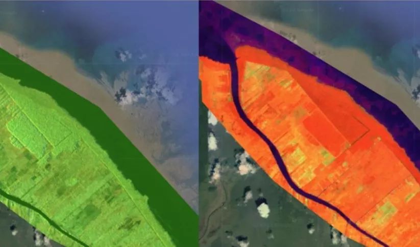
The Monitoring and Evaluation of Mangroves in Guyana service brings Synthetic Aperture Radar (SAR) and other remote sensing resources to map the extent and structure of mangrove forests along the coast of Guyana.
-
Monitoring of Gold Mining in the Peruvian Amazon
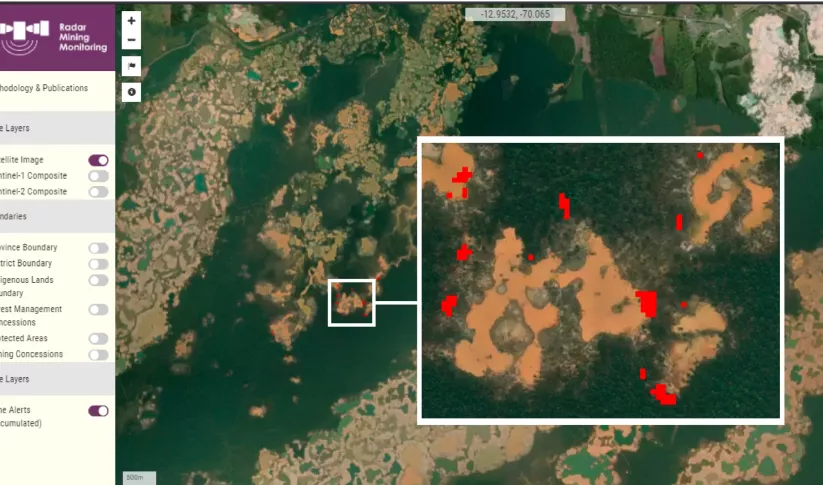
The Monitoring of Gold Mining in the Peruvian Amazon service produces near real-time information on deforestation and mining activity in the southern Peruvian Amazon.

