Announcement NASA Announces New SERVIR Applied Sciences Team After a multi-round solicitation process, NASA has selected the 20 projects comprising the next SERVIR Applied Sciences Team. November 1, 2019
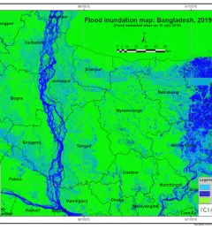
Articles & Stories Taking stock of the damage: Mapping the impact of the 2019 Bangladesh floods using satellite imagery In view of the recent flooding events in South Asia, ICIMOD has prepared flood inundation maps by analysing freely available satellite imagery. These maps provide a synoptic overview of the extent of the inundation caused by the floods and can aid disaster management agencies in prioritizing relief and rescue activities in flood-affected areas. August 10, 2019
Articles & Stories Mekong River Commission Utilizes Space Technology to Improve Flood Forecasting Lower Mekong countries suffer from the effects of seasonal flooding and flash flooding caused by monsoon rains and tropical storms. Regional and national level organizations and agencies require a range of information, forecasts, and decision-support tools to better prepare for, monitor, issue warnings, and respond to flood risk. August 8, 2019
Articles & Stories Dancing rivers of Myanmar – mapping moves from space Changes in river morphology including floods, erosion, and landslides are affecting ecosystem habitats and the lives and livelihoods of communities living along Myanmar's rivers. SERVIR-Mekong is using satellite-based monitoring tools to support Myanmar agencies and communities to manage the risks better. July 3, 2019
Articles & Stories Preparing for the 2019 floods in Bangladesh To ensure effective preparation for any upcoming floods in 2019, the Bangladesh Water Development Board (BWDB), Flood Forecasting and Warning Centre (FFWC), with support from the International Centre for Integrated Mountain Development (ICIMOD), held a stakeholder consultation workshop in Dhaka on 5 March 2019. May 15, 2019