Articles & Stories SERVIR Profile of Phoebe Oduor Meet Phoebe Oduor, Greenhouse Gas Inventories and Land Use Land Cover Thematic Lead for RCMRD/SERVIR-Eastern and Southern Africa. December 7, 2017
Articles & Stories SERVIR Profile of Nguyen Hanh Quyen Meet Nguyen Hanh Quyen, Remote Sensing Officer for ADPC/SERVIR-Mekong. December 6, 2017
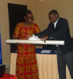
Articles & Stories World Bank and SERVIR working together to map for Natural Capital Accounting in Rwanda SERVIR-Eastern and Southern Africa (E&SA) at the Regional Centre for Mapping of Resources for Development (RCMRD), together with the government of Rwanda, recently released new 2015 land cover maps, disseminating them during a workshop in May 2017 in Kigali. June 22, 2017
Events Webinar on Remote Sensing for Forest Change Detection In the context of the U.S. Agency for International Development (USAID)-funded SilvaCarbon initiative, the US Forest Service (USFS) will be hosting a webinar to introduce an online training course on Remote Sensing for Forest Cover Change Detection using freely available, open source software (QGIS and Google Earth Engine). April 14, 2017
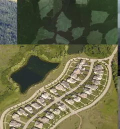
Articles & Stories Adding new tools for tracking a changing landscape Monitoring land cover change over time is essential to understanding ecosystem health, biodiversity, forest carbon cycling, and much more. Land cover/land use (LCLU) data and maps are critical components for climate monitoring applications such as Greenhouse Gas (GHG) emissions reports. March 23, 2017