Articles & Stories
SERVIR Guides Flood Protection in Kenya
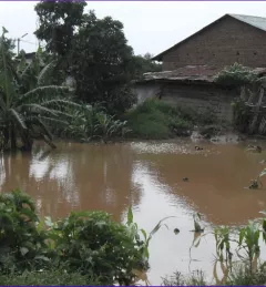
Like many rivers across the world, the Nzoia River in western Kenya pushes over its banks each year. In recent years, to protect lives and property in Kenya, SERVIR-Eastern & Southern Africa (E&SA) at the Regional Center for Mapping of Resources for Development (RCMRD) has provided high-accuracy flood level scenario maps to the World Bank to guide their flood protection dike repairs in the region.