Strategy & Guidance USAID Geospatial Strategy USAID’s 2024-2028 Geospatial Strategy promotes leveraging the power of geospatial data and technology to target the delivery of international programs. November 15, 2023
Use Case Use Case: Greening Prey Lang Greening Prey Lang, a USAID program, used Collect Earth Online (CEO) as part of their efforts to protect critical forestland in Cambodia and improve the lives of the people who live there. February 17, 2022
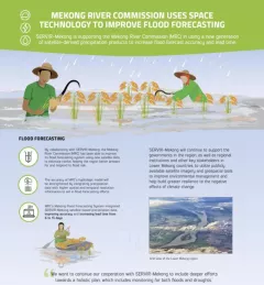
Infographic Mekong River Commission Uses Space Technology to Improve Flood Forecasting SERVIR-Mekong is supporting the Mekong River Commission (MRC) in using a new generation of satellite-derived precipitation products to increase flood forecast accuracy and lead time. December 13, 2020
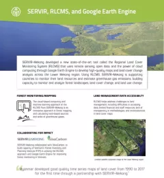
Fact Sheet Fact Sheet: Regional Land Cover Monitoring System SERVIR, RLCMS, and Google Earth Engine SERVIR-Mekong developed a new state-of-the-art tool called the Regional Land Cover Monitoring System (RLCMS) to develop high-quality maps and land cover change analysis across the Lower Mekong region. December 13, 2020
Use Case Use Case: Mekong River Commission The Mekong River Commission (MRC) is an intergovernmental organization that provides coordination and technical input on flood management to the members of the Lower Mekong countries including Cambodia, Lao PDR, Thailand, and Vietnam. August 31, 2020