Strategy & Guidance USAID Geospatial Strategy USAID’s 2024-2028 Geospatial Strategy promotes leveraging the power of geospatial data and technology to target the delivery of international programs. November 15, 2023
Use Case Use Case: Nepal Forest Research Training Centre How the Nepal FRTC used the Regional Land Cover Monitoring System The FRTC, which is under the jurisdiction of Nepal’s Ministry of Forests and Environment, is the government-sanctioned organization that is responsible for forestry research and survey activities at the national level. September 28, 2020
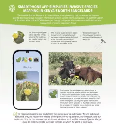
Infographic Kenya Invasive Species Mapper Smartphone app simplified invasive species mapping in Kenya's north rangelands The Invasive Species Mapper is a citizen-science smartphone app that crowdsources invasive species detection to give managers information on their current extent and spread.