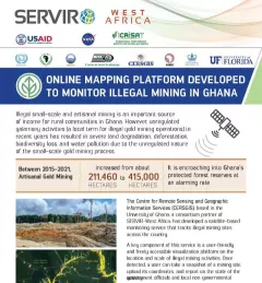
Fact Sheet Fact Sheet: Online Mapping to Fight Illegal Mining in Ghana This fact sheet highlights efforts to monitor illegal mining in Ghana. December 23, 2020
Training Mapping and Monitoring Mangroves using Google Earth Engine A Virtual Workshop hosted by SERVIR Amazonia This workshop is the third in a series offered by SERVIR Amazonia focused on using remote sensing to monitor mangroves in Guyana. December 15, 2020
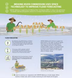
Infographic Mekong River Commission Uses Space Technology to Improve Flood Forecasting SERVIR-Mekong is supporting the Mekong River Commission (MRC) in using a new generation of satellite-derived precipitation products to increase flood forecast accuracy and lead time. December 13, 2020
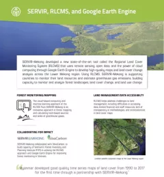
Fact Sheet Factsheet: Mekong Regional Land Cover Monitoring System (RLCMS) SERVIR, RLCMS, and Google Earth Engine December 13, 2020
Strategy & Guidance SERVIR Strategic Plan 2020-2025 This strategic plan identifies the next set of cross-cutting strategic priorities that will ensure SERVIR remains responsive to both NASA and USAID Agency goals and those of stakeholders and users in SERVIR regions. October 10, 2020