Tool
SERVIR Service Planning Toolkit
The Service Planning Toolkit is a resource for SERVIR Hubs and their partners to implement SERVIR's service planning approach.

6 results
The Service Planning Toolkit is a resource for SERVIR Hubs and their partners to implement SERVIR's service planning approach.
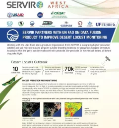
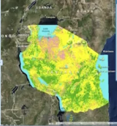
This fact sheet highlights how SERVIR is using satellite data to pinpoint breeding locations for locusts so that the pests can be eradicated before they take flight.
SERVIR improves local and regional capacity to provide tools, products, and services that empower decision makers to better address critical issues related to food security, water resources, natural disasters, land use, and extreme weather. Building on thirteen years of experience, SERVIR has grown in its geographical reach and has adapted its approach based on lessons learned.
A single desert locust can consume its body weight in vegetation in one day. When 40 million of them gather, they can devour as much food as 35,000 people.

ClimateSERV is a web-accessible system that allows users to access, visualize, and analyze historical Earth observations useful to decision-making across multiple sectors.
To sustainably manage forest landscapes, governments and decision makers need accurate and up-to-date information on the extent of the forests they manage and the ways they are changing.