
Enabling Sustainable Landscape-Scale Agricultural Management through Fire and Air Quality Monitoring
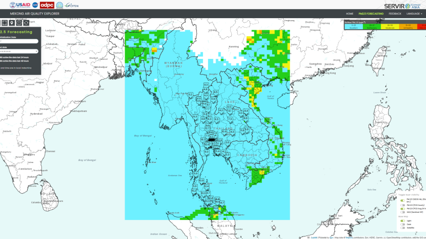
The Enabling Sustainable Landscape-Scale Agricultural Management through Fire and Air Quality Monitoring service guides authorities to regulate agriculture burning and manage forest fires using the Mekong Air Quality Explorer Tool, which combines air quality estimations from NASA's GEOS-5 global model with local ground-sensor data and machine-learning analytics. Currently operational in Thailand, this service will soon cover the entire Lower Mekong region, helping authorities devise data-driven policies and strategies to tackle issues related to agricultural burning and forest fires.
The service ended in September 2022. Development of a follow-on project, Air Quality Monitoring for Sustainable Landscape and Better Human Health, began in 2023.
Rationale
Over the past decade, the Lower Mekong region has faced major landscape challenges caused by deforestation, human-induced burning of agricultural areas, and forest fires. Fires emit carbon dioxide (CO2) and other greenhouse gasses (GHGs) into the atmosphere further leading to decreased air quality and elevated public health concerns. Air quality data obtained from remote sensing, combined with data from ground stations enables authorities to design better response strategies to tackle air pollution, particularly from agricultural burning and forest fires – the two major causes of air pollution and transboundary haze across the Lower Mekong region.
-
Users
Thai Pollution Control Department (PCD)
Geo-Informatics & Space Technology Development Agency (GISTDA)
Rajamangala University of Technology Lanna
Thai Northern Provincial Center for Solving Haze Problem and Forest Fire Control
United Nations Economic and Social Commission for Asia and the Pacific (UNESCAP)