
Flood Monitoring in Specific Basins in Colombia
The service utilizes Google Earth Engine and the available LandSAT and SENTINEL data collections, spanning from 2014 to the present date, to determine water surface areas within specific date ranges. By utilizing the powerful capabilities of Google Earth Engine and integrating data from multiple sources, the service provides valuable insights into water dynamics and helps in understanding the distribution of permanent water bodies and the occurrence of flood events.
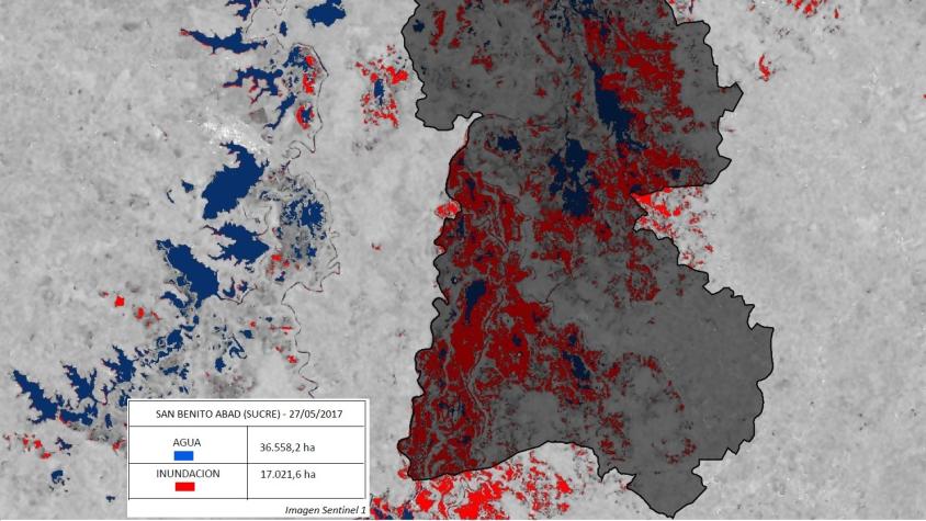
The service estimates the extent of water surfaces by leveraging advanced algorithms and analyzing satellite imagery. The estimated water surface is then compared to the JRC Global Surface Water Mapping Layers 1.4 catalog to differentiate between permanent water bodies and areas affected by flooding. This comparison enables the identification and distinction of areas that consistently maintain water bodies from those that have experienced temporary flooding.
Rationale
Having access to this tool would be crucial for several reasons. Firstly, it allows for accurate and timely identification of water surfaces within specific date ranges using freely accessible satellite imagery, which is essential for various applications such as hydrological modeling, water resource management, and environmental monitoring. Secondly, the ability to differentiate between permanent water bodies and areas affected by flooding provides valuable information for disaster response and mitigation efforts. This tool enables decision-makers to prioritize areas at higher risk of flooding and allocate resources accordingly. Additionally, the integration of data from the JRC Global Surface Water Mapping Layers enhances the accuracy and reliability of the results, further improving the understanding of water dynamics at a global scale. Overall, having this tool at our disposal empowers us to make informed decisions, promote sustainable water management practices, and enhance our resilience to water-related challenges.
Furthermore, this tool provides valuable insights into the impacts on agriculture and urban areas caused by past flooding events of certain magnitudes. By analyzing historical data, it enables us to identify areas that have been prone to flooding in the past and assess the potential vulnerability of these regions in the future. This knowledge is crucial for developing effective strategies and implementing proactive measures to mitigate the impacts of future flooding events. By understanding the extent and severity of flood-affected areas, we can better prepare and allocate resources to minimize damages, protect livelihoods, and enhance the resilience of agricultural and urban systems.
-
Users
Centro Nacional de Monitoramento e Alertas de Desastres Naturais (CEMADEN) - Brazil
Servicio Nacional de Meteorología e Hidrología (SENAMHI) - Peru
Instituto de Hidrología, Meteorología y Estudios Ambientales (IDEAM) - Colombia
Instituto Nacional de Meteorología e Hidrología (INAMHI) - Ecuador