
Supporting Climate Adaptation and Mitigation through Land Use/Land Cover Mapping in Myanmar
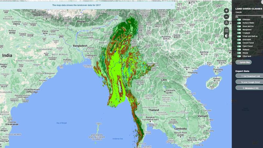
The Supporting Climate Adaptation and Mitigation through Land Use/Land Cover Mapping in Myanmar service was a collaboration between SERVIR Mekong, SERVIR Hindu Kush Himalaya, OneMap Myanmar, and the Myanmar Forest Department to develop a National Land Cover Monitoring System (LCMS). The LCMS is a web-based tool developed using the cloud-based Google Earth Engine, which uses historical Landsat Satellite series (Landsat 5, 7, & 8) to produce wall-to-wall land cover maps on a yearly basis starting from 1990 to the present for land cover monitoring purposes. To validate and improve the accuracy of these maps, the service used Collect Earth Online to collect reference data in addition to available ground-truth data. The land cover products generated by the service supported national-level land use/land cover assessments and reporting to the Food and Agriculture Organization of the United Nations (FAO) Forest Resource Assessment (FRA) and the United Nations Framework Convention on Climate Change (UNFCCC).
The service was co-developed with the Myanmar Forest Department and other stakeholders to ensure their ability to operate and improve upon the service whennew ground-truth data are obtained. It provided capacity-building for the Forest Department of Myanmar to maintain and operate the National LCMS and ensure its sustainability. The land cover maps generated from this service are free and openly available for the public to use, enabling further analysis. The service supported Myanmar in fulfilling its commitments at a global level for managing forest resources and meeting the targets of the UN Millennium Development Goals by providing a baseline of land cover datasets and a tool to support land use planning.
Rationale
According to the FAO FRA reports, Myanmar's forest cover drastically declined from 58% in 1990 to 43% in 2015 when the country began practicing an open market economic system. Myanmar has also experienced negative impacts from climate change in recent years including natural disasters caused by devastating cyclones, monsoon floods, drought, and abnormal rainfall patterns. To monitor the resulting changes in land and forest cover, Myanmar conducted a FRA and produced land cover maps. However, these efforts revealed a need for more consistent and frequent land cover maps to aid in mitigating the impacts from climate change and to assess the state of the environment for monitoring and planning purposes. To address this need, this service is being implemented through a series of efforts involving stakeholder consultations with end users, defining the land cover typology of Myanmar, data collection, and capacity building.
Myanmar adopted the Paris Agreement Convention within the UNFCCC and is developing a new sustainable land use policy. Land cover maps generated by this service will enable Myanmar to be more transparent in reporting the status of forest resources to the FAO FRA and UNFCCC. The national LCMS will produce three land cover datasets for FRA, UNFCCC and national level. From these maps, the forest cover status will be submitted to the FAO, and the land cover change, which can contribute to greenhouse gas emission, will be reported to the UNFCCC/Intergovernmental Panel on Climate Change.
-
Users
Forest Department of Myanmar
Myanmar Environmental Conservation Department
Ministry of Natural Resources and Environmental Conservation (MONREC)
-
Training Materials
-
SERVIR HKH News
Developers Improve Land Use Monitoring from Space
SERVIR-Mekong Regional Land Cover System Showcased in First State of Land Report
Google Earth Engine 'roadshow' continues in Myanmar
SERVIR-Mekong grantees showcase research on geospatial applications for resilience
Building Capacity in the Mekong Region to Monitor Land Cover