Blog SERVIR Workshop Tackles Transboundary Trouble in the Amazon 
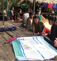
In June, SERVIR Applied Sciences Team members Dr. Stephanie Spera and Dr. David Salisbury, geographers at the University of Richmond, organized a workshop in Pucallpa, Peru. September 28, 2022
Articles & Stories Locally Led Development Drives Climate Action at the SERVIR Amazonia Hub SERVIR Amazonia supports sustainable development throughout the Amazon region by strengthening the capacity of governments and other key stakeholders through the integration of Earth Observation and geospatial technologies. The hub strives to build capacity to improve decision-making and to better incorporate the voice of women, indigenous peoples and their communities. March 26, 2022
Articles & Stories Geospatial services for climate-smart environmental decision-making in the Brazilian Amazon In line with its service co-development approach, SERVIR-Amazonia is bringing diverse Brazilian stakeholders together to identify local development problems and identify solutions in form of tools, data sets, training resources and capacity building activities that use satellite data, Earth science, and geospatial technologies. May 28, 2021
Articles & Stories Protecting Amazonia Forests by Mapping Forest Degradation Using Cloud-Penetrating Satellite Imagery One of the major challenges in monitoring forests is identifying forest degradation processes. Recent years have seen advancements in satellite remote sensing technology, which has in turn revealed changed patterns of illegal deforestation activity in the Amazon rainforest. August 4, 2020
Articles & Stories Applied Sciences Team project informs decision makers with fire season forecast SERVIR AST member Doug Morton discusses the upcoming fire season in Amazonia in a new NASA article. July 11, 2020