
Use Case: Bangladesh Flood Forecasting and Warning Centre (FFWC)
User: Flood Forecasting and Warning Centre (FFWC), Bangladesh Water Development Board (BWDB), Ministry of Water Resources (MoWR)
SERVIR Hub: SERVIR-Hindu Kush Himalaya (SERVIR-HKH)
Geographic Location: Bangladesh
User Background: The Flood Forecasting and Warning Centre (FFWC), which falls under the jurisdiction of the Bangladesh Water Development Board (BWDB) of the Ministry of Water Resources (MoWR), is the national agency that provides flood forecast and flood warning information for all of Bangladesh. FFWC coordinates flood disaster mitigation and management efforts prior to, during, and after the monsoon season and works in close consultation with government ministries and agencies, such as the Bangladesh Meteorological Department, Department of Disaster Manage-ment, and Department of Agricultural Extension.
Service Summary: Enhancing Flood Early Warning Services (EWS) aims to build the resilience of vulnerable communities in the Hindu Kush Himalayan (HKH) region by increasing flood forecast lead times and hosting the information on an interactive web platform. The service will include an operational 15-day flood forecast based on the downscaled Global Flood Awareness System (GloFAS) forecasting system using the Routing Application for Parallel Computation of Discharge (RAPID) model at designated locations agreed to by the partner agencies in Bangladesh and Nepal.
Enhancing Flood Early Warning Services in Hindu Kush Himalaya
Situation: Bangladesh is positioned downstream of the three main rivers (Ganges, Brahmaputra, and Meghna) that flow into the country. In fact, 92% of the total surface area of these three rivers, which includes watersheds and basins, is located outside Bangladesh’s national boundary. During the monsoon season, Bangladesh experiences recurring flooding, which heavily impacts the livelihoods and properties of people that live along the floodplains of these rivers. Given that this flooding originates far upstream and outside of Bangladesh’s national border, it is difficult to obtain reliable river flow data that could help the country mobilize and prepare for the sudden onset of flooding.
User Need: Previously, the FFWC relied on hydrological monitoring data from 94 water-level stations and 70 rainfall stations throughout Bangladesh. In 1992, FFWC installed a flood forecasting model called MIKE11, which initiated probabilistic medium-range flood forecasts with lead times of up to 10 days at 18 locations within the Ganges-Brahmaputra basin. FFWC also introduced an interactive voice response system that disseminates early warning information via mobile phones.
However, despite progress, the FFWC only has access to river flow data once a river has actually entered into Bangladesh’s national boundary; it does not have access to upstream river flow data outside its national boundary that could better support hydrological modeling and flood forecasting. As a result, its flood forecasting capability is currently limited to three to five-day lead times. These predictions are based upon a deterministic model that is integrated into an outdated ArcView geospatial interface.
User Quote:
"Our current flood model uses flow information from 17 boundary locations. Earlier we did not have any flow information for those locations. With the SERVIR forecasting tool now in place, we have flow estimates on all these boundary locations. It provides us guidance on the floods and is fed into our in-house model. We were able to capture flood peaks two times this year." (2018)
– Md Arifuzzaman Bhuyan, Executive Engineer, FFWC, BWDB
Example of Use: In order to help FFWC improve upstream river flow data, SERVIR-HKH, in collaboration with Brigham Young University (BYU), customized the Streamflow Prediction Tool, an open source web application that provides 10 to 15-day probabilistic forecasts at 21 locations along the Bangladesh border. This tool is particularly useful as it provides a user interface that generates outputs and ancillary statistics that are pertinent in supporting forecast decision-making.
During flooding situations in 2018 and 2019, the FFWC used the app’s data as inputs into its own hydraulic model and flood mapping applications. SERVIR-HKH carried out multiple stakeholder consultations and training events for FFWC staff regarding the development and use of the Streamflow Prediction Tool, as well as understanding the tool’s forecast validation and data processing. In late 2019, in response to the FFWC’s request, SERVIR-HKH expanded the number of transboundary river locations from 17 to 21. This additional data collection has helped to further improve the accuracy of FFWC’s flood forecasting models.
SERVIR-HKH also collaborated with FFWC to develop a custom Android application, BWDB Flood App, to make flood warning information more accessible to the public. The mobile application pushes flood information published on FFWC’s website and makes the data readily available on Android phones for field staff and people living in areas vulnerable to flooding.
The FFWC is using observational data from select boundary locations to validate the forecasts generated by the Streamflow Prediction Tool for Bangladesh.
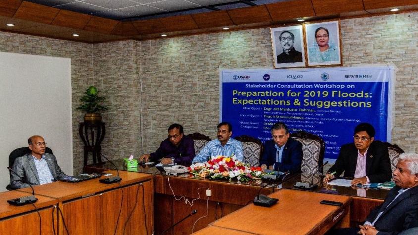
In February 2019, FFWC and BWDB, with additional support from SERVIR-HKH, organized stakeholder consultation workshops in advance of the monsoon season. The workshops, which were the first of their kind, took place in Dhaka, Serajgonj and Bogra, with the latter two cities representing two of the most vulnerable flood hotspots in all of Bangladesh.
At the Dhaka workshop, the FFWC invited senior officers from different divisions within the BWDB, representatives from the Bangladesh Meteorological Department (BMD), Institute of Water Modelling (IWM), Department of Disaster Management (DDM), Department of Agriculture Extension (DAE), SERVIR-HKH, and members of the Bangladeshi media. The convening parties established a quorum on the FFWC’s improved flood forecasting abilities and the mobile application.
Outcome of Use: The FFWC is actively using the Streamflow Prediction Tool to support its flood forecast. During the last two monsoon seasons, the agency obtained reliable baseline inputs which helped to provide accurate forecasts during major flooding events.
The FFWC is using observational data from select locations to validate the forecasts that are being generated by the Streamflow Prediction Tool for Bangladesh.
The inaugural pre-monsoon stakeholder workshops received positive feedback and media coverage. As a result of this initial success, FFWC and BWDB plan to organize stakeholder workshops every year prior to the monsoon season.
Future Collaborations: The partnership between SERVIR-HKH and FFWC will continue, especially as the benefits from the services are realized and users begin to display confidence in the flood predictions. Currently, SERVIR-HKH and FFWC are carrying out a joint validation process of the flood forecasting predictions, which will continue into the future.
SERVIR-HKH and FFWC continue to hold discussions on how to best apply existing tools and products to create end-to-end water resource systems and early warning information systems.
Data continues to be shared more widely across the various stakeholders. This sharing of data encourages more connections and collaborations to take place between researchers.
Additional Documents: https://servir.icimod.org/news/preparing-2019-floods-bangladesh