Strategy & Guidance
USAID Geospatial Strategy
USAID’s 2024-2028 Geospatial Strategy promotes leveraging the power of geospatial data and technology to target the delivery of international programs.

3 results
USAID’s 2024-2028 Geospatial Strategy promotes leveraging the power of geospatial data and technology to target the delivery of international programs.

The Supporting Better Riverine and Flash Flood Forecasting for the Lower Mekong service improves riverine flood forecasts and enhances flash flood guidance monitoring in the region.
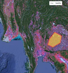
Through the Supporting Flood Emergency Preparedness for Myanmar Service, SERVIR Mekong co-developed and supported the use of a systematic decision-support tool for the Myanmar Department of Disaster Management to identify areas with high flood risk.