Strategy & Guidance
USAID Geospatial Strategy
USAID’s 2024-2028 Geospatial Strategy promotes leveraging the power of geospatial data and technology to target the delivery of international programs.

3 results
USAID’s 2024-2028 Geospatial Strategy promotes leveraging the power of geospatial data and technology to target the delivery of international programs.
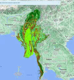
The Supporting Climate Adaptation and Mitigation in Myanmar service was a collaboration between SERVIR and Myanmar develop a National Land Cover Monitoring System, a web-based tool created using the cloud-based Google Earth Engine.

ClimateSERV is a web-accessible system that allows users to access, visualize, and analyze historical Earth observations useful to decision-making across multiple sectors.