
Regional Land Cover Monitoring System - Hindu Kush Himalaya
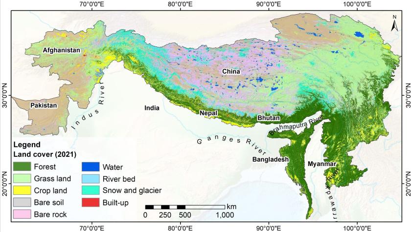
SERVIR-HKH has developed land cover monitoring systems with a modular architecture built on the Google Earth Engine (GEE) computational platform. These systems enabled the development of land cover maps at national and regional scales and any desired temporal frequency. SERVIR-HKH Collaborated with SERVIR-Mekong at Asian Disaster Preparedness Center (ADPC), Afghanistan’s Ministry of Agriculture, Irrigation and Livestock (MAIL), Bangladesh’s Forest Department (BFD), Nepal’s Forest Research and Training Centre FRTC), Myanmar’s Forest Department, SilvaCarbon, the Global Land Analysis and Discovery (GLAD) laboratory at the University of Maryland as part of the NASA Applied Science Team (AST) project, the United States Forest Services, and SERVIR team members at the Coordination Office (SCO). The outputs of this project helps support forest management and degradation monitoring efforts. As of Earth Day 2022, the National Land Cover Monitoring System (NLCMS) of Nepal was launched and endorsed as the official mapping system of Nepal, essential for IPCC and NDC reporting (Article). The RLCMS platform is a critical building block for the entire South Asia region and will be used for forest carbon tracking along with other essential monitoring efforts.
Rationale
Land cover mapping is one of the most common applications of Earth Observation (EO), which plays a vital role in providing meaningful information about the Earth’s surface. In the Hindu Kush Himalayan (HKH) region, land cover changes are occurring at an alarming rate due to the combined effects of rapid economic growth and population pressures. These changes pose significant challenges to the long-term sustainability of ecosystems and the essential services they provide, such as food, water, and energy. Unfortunately, there is a considerable data gap in accessing regularly updated land cover information for effective change detection, monitoring, planning, policy formulation, management, and meeting national and international reporting requirements. Addressing this data gap is crucial for informed decision-making and implementing sustainable land management practices in the HKH region.
Further, tracking of forest carbon and its dynamics are essential to meet the sustainable development goals and climate change mitigation action such as REDD+. This service also aims to examine above ground forest carbon stock (AFCS) estimation via locally calibrated methods using open source EO data and field measurement data and strengthen the capacity of stakeholders on AFCS assessment with specific focus to Nepal and Bangladesh.
-
Users
Nepal Forest Research and Training Center
REDD Implementation Centre, Nepal
Afghanistan Ministry of Agriculture Irrigation and Livestock
Bangladesh Forest Department
Forest Department, Myannmar
Ministry of Natural Resources and Environmental Conservation (MoNREC), Myanmar
-
SERVIR HKH News/Resources
Can spatial land-use planning help overcome environmental and development challenges in the CHT?
Blog-capacity building on forest carbon
Natural coastal land expansion offers hope to low-lying Bangladesh
Earth Day 2022 celebrations – #InvestInOurPlanet
Success Story: Analyzing land use change for improved decision making
Success Story: Mapping land cover: High-resolution annual land cover data for the HKH region
Project page: Regional Land Cover Monitoring System for the Hindu Kush Himalaya
