Articles & Stories
SERVIR Profile of Finu Shrestha

Meet Finu Shrestha, GIS Research Associate for ICIMOD/SERVIR-Hindu Kush Himalaya.

19 results
Meet Finu Shrestha, GIS Research Associate for ICIMOD/SERVIR-Hindu Kush Himalaya.

ICIMOD, under its SERVIR-Hindu Kush Himalaya (SERVIR-HKH) and Climate Services for Resilient Development (CSRD) Initiatives, is collaborating with technical organizations in the United States and meteorological and agricultural institutions in the HKH to establish a regional agricultural drought monitoring and early warning system.

The Hindu Kush Himalayan (HKH) region is no stranger to water- and weather-induced hazards. Every year, these disasters result in loss of lives, livelihoods, and damage to infrastructure throughout HKH countries.

The SERVIR program, launched in 2005, connects NASA, U.S. researchers, a network of development partners around the world, and companies like Google to harness the power of satellite observations — helping countries see, with greater clarity, how their environments affect well-being and safety.
![SHUKLA_Shrad_photo[1].jpeg](/sites/default/files/styles/card_flag/public/article/image/SERVIR-HKH_thematic_illustration.jpg.webp?itok=isSkllDk)
The International Centre for Integrated Mountain Development (ICIMOD) has been implementing the SERVIR-HKH Initiative — one of five regional hubs of the SERVIR network — in its Regional Member Countries, prioritizing capacity building and science activities in Afghanistan, Bangladesh, Myanmar, Nepal, and Pakistan.
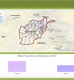
Wheat is one of Afghanistan's largest agricultural products, yet current production levels fail to meet increasing demand, and wheat remains one of the nation's biggest imports.
|Megan Kirchner, Communications Intern for the NASA SERVIR Science Coordination Office
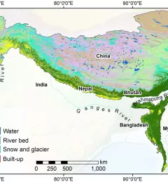
SERVIR-HKH has developed land cover monitoring systems with a modular architecture built on the Google Earth Engine (GEE) computational platform.
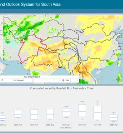
The Regional Drought Monitoring and Outlook System (RDMOS) was developed to help predict, mitigate, and adequately respond to drought vulnerabilities in the HKH region.
This service improves air quality monitoring through a web-based dashboard that was developed that utilizes publicly available observation data, satellite-based remote sensing products, and atmospheric models.